No More Manual Measurements: Make Way for AI Landscape Measuring Software
Subscribe to get updates from Attentive!


Landscape measuring tools can make or break your entire sales process. No, we're not overstating it. Time & cost spent on takeoffs are costing you more than you know. So, are you using the latest landscape measuring software in your estimation workflow?
Suppose you still have to measure the property manually using a measuring wheel, guesstimating, or clicking away on online tools like Google Earth, etc. In that case, you’re missing out on the latest technology that can save you loads of time & money.
Ever faced the hassle between receiving a Request for Quote (RFQ) or Proposal (RFP) and finally sealing the deal? There are several steps involved - like measuring, estimating, and creating proposals. And guess what? Accurate landscape measurement is key if you're aiming for a spot-on detailed cost-based estimate.
Gone are the days when this meant loads of manual work. Thanks to AI, you can now breeze through the measuring process, landing accurate estimates that account for each & every cost much faster.
This one's for you, landscapers who are still hooked on manual tools or, let's be honest, sometimes just wing it with rough guesses. Don't let your hard-earned marketing efforts be in vain because of off-the-mark quotes or measurement slip-ups.
The Estimator’s Timeline
One way to understand what’s new in measurements is to look at history and compare all the measuring methods that have ever existed for the landscaping industry.
Let’s start by looking at this timeline:
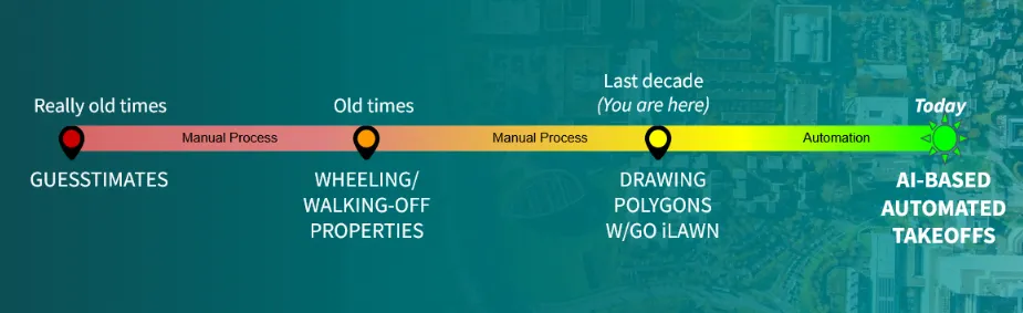
Remember the days of guessing game estimations? Or rolling out the measuring wheel and spending hours on-site? We've even tried manual landscape measuring software. Sure, it's better than on-site visits, but you're still stuck clicking and drawing for ages.
Still using these old-school methods? It's time to leave them in the past. The future's here, and it's brilliant.
Enter the era of AI-powered, fully automated site measurements. No more sweat and hours spent on measuring. Now, you can focus all that energy on your customers and growing your business.
This way, you measure faster. Send out estimates to your sales teams, who, in turn, close deals & crush their sales quotas.
From Manual Takeoffs To AI Landscape Measuring Software
Let's dive into each of the manual measuring methods and see how far we've come:
Manual Takeoffs- The Olden Days
Your team performs landscape measurements for commercial properties by visiting the site. They either guess or use measuring wheels, tapes, lasers, transit levels, etc., or spend their entire day drawing polygons on now-outdated software. They then calculate cost-based estimates and construct bids. Not getting any returns after all the effort and money spent is depressing. Let's weigh all their pros and cons-
a. Eyeballing:
- Pros: The pro of being dependent solely on your eyes is zero investment in manual labor or measuring apparatus. If you’re outdoorsy and also the one managing the account, you get to scope the field personally. This helps generate quick bids, as you are not spending hours on manual measuring.
- Cons: Since it’s an approximation, there will always be scope for human error. Guessing is seldom accurate. This technique incurs hidden costs. Inaccurate quotes can harm your business in two ways:
- Losing bids to competition due to overbidding and
- Losing out on profit margins due to underbidding.
b. Landscape measuring tools, e.g., measuring wheel:
- Pros: If you do not mind investing a huge chunk of your time and resources on dedicated AMs walking-off properties, then this is for you. This method allows your AM to spend more one-on-one time with the client and build a good relationship with him.
- Cons: Traditional measuring has a lot of potential for error and is cost and time-intensive because of:
- Fuel costs for driving up to sites.
- Regular upkeep of measuring tools.
- High wages of dedicated AMs wasted on low-value work like measuring properties
- Inaccurate, unoptimized bids due to human errors.
- Your proposal turnaround time goes for a toss, as the estimate is made manually.
- You’re wasting valuable sales hours that you should rather spend on winning the client over and growing your business.
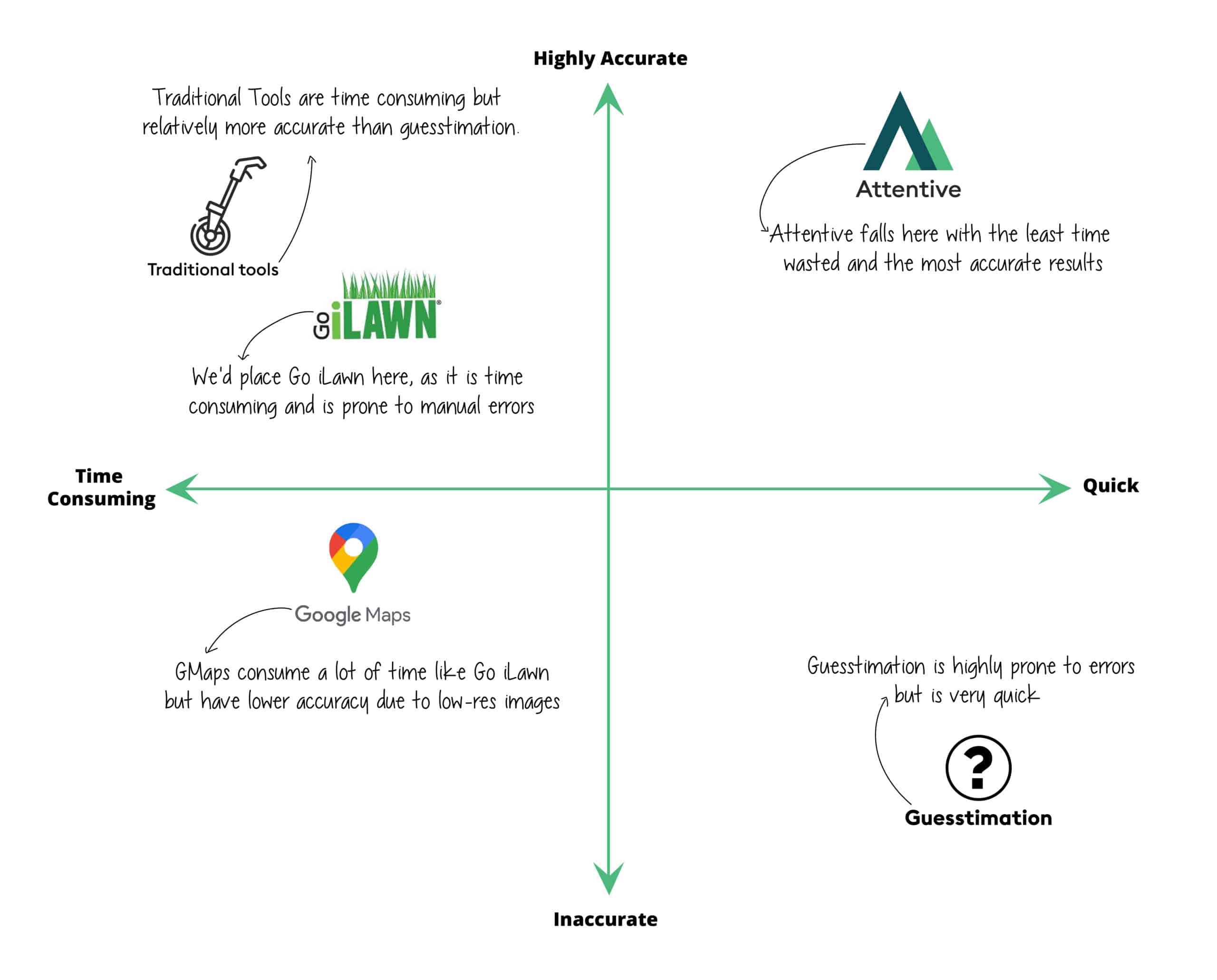
c. Manual landscape measuring software:
- Pros: Softwares like Go iLawn and Google Maps create quick takeoffs compared to on-site tools. They are relatively less resource intensive, too, as there is 0 travel time and expense.
- Cons: Time-consuming as every polygon is hand drawn on aerial images of the property. It is strenuous to zoom in and out of maps. Overall, it results in lower productivity, slower turnaround time, and errors in the estimate. Besides, sometimes the map images are outdated and non-HD as well.
AI-Driven Automated Landscape Measurement - The Golden Days
Accurate takeoffs are of utmost importance.
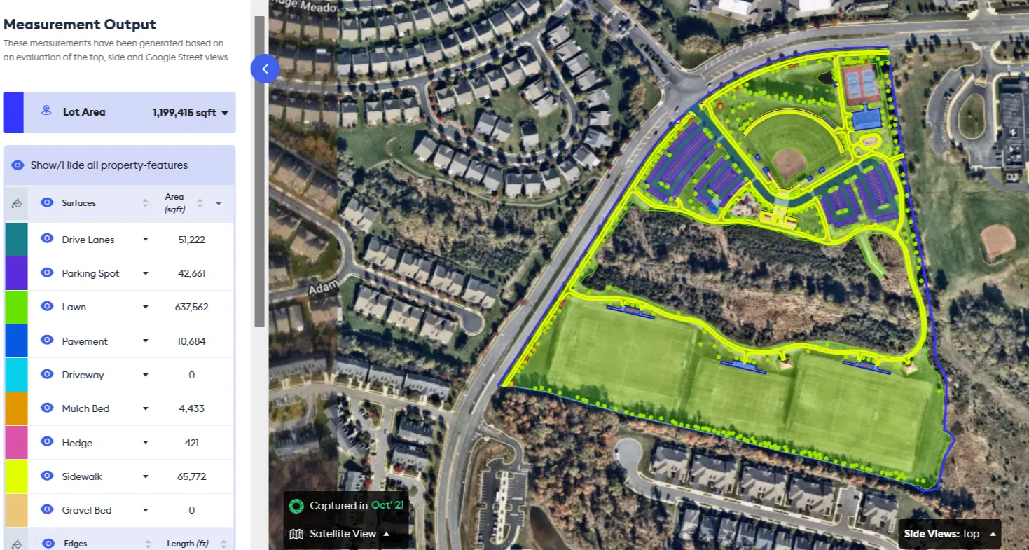
Now, you don’t have to go through the hassle of drawing polygons endlessly. You can fully depend on automated takeoff software for precise takeoffs on up-to-date, high-resolution imagery. This reduces estimation time by 90%.
What’s more? A takeoff request can be generated from anywhere, even on mobile devices. All you need to do is sit back and wait for the fully automated takeoff.
You can save your account manager’s time with Attentive.ai's automated takeoff software that allows you to set up a measurement in a jiffy and run multiple takeoffs parallelly. You can queue up to 10 takeoffs as well.
It is time to adopt AI and ditch the old landscape measuring software.
The following illustration is a perfect summary of why one should pick the AI-driven software :
This page is intended as a source of important information to consumers and assist them in making rational purchase decisions.
All trademarks, copyrights (if any), and other intellectual property used herein and not owned by Attentive.ai belong to their respective owners or licensees (as applicable), and Attentive.ai makes no claim of owning or having rights to such trademarks, copyrights, or other intellectual property that is not owned by it or validly licensed to it.
FAQs
How do you measure landscaping?
Traditional landscaping measurement involves manual tools like measuring wheels, polygon software, or laser measures. However, the latest AI-driven automated landscape measuring software, like Attentive.ai, means you automate your takeoffs. Save 95% of your time by just entering the address, confirming the lot boundary, and hitting proceed. Your takeoff, built on high-res aerial imagery, will directly reach your inbox.
What is the margin for landscaping business?
The profit margin for a landscaping business varies, but generally, a healthy margin ranges from 15% to 45%. This margin depends on several factors, including the accuracy of estimates, operational efficiency, and control of overhead costs.
How do I make a landscaping estimate?
Your landscaping estimate should be detailed, cost-based, and reflective of the project's scope, ensuring accuracy and profitability. Start with accurate property measurements using an AI-driven landscape measuring tool, Attentive.ai, and factor in the following elements, including material costs, labor costs, equipment rental, subcontractor expenses, scheduling costs, overhead costs, profit margin, and contingency fund.


.webp)

